Saturday, March 9, 2013

Chapter Ten- The Coastal South

New Orleans is located in the Coastal South, an area that includes the land and offshore islands along the coast of the Atlantic Ocean and the Gulf of Mexico from Virginia southward and westward to south Texas (per The Geography of North America, 2nd Edition).

This region is the fastest growing area of the nation and contains many prime tourist destinations.  Miami, Orlando, Charleston, Savannah, and Myrtle Beach are all found in the Coastal South. New Orleans is also a top tourist destination.

The appeal of New Orleans reaches many different types of people with different interests. There is almost something for everyone. Foodies can indulge in wonderful meals. History buffs can tour historic homes and old cemeteries. Civil War enthusiasts can visit important war sites. Fans of the supernatural have an abundance of ghost tours to choose from or they can visit the former home of the immensely popular author, Anne Rice in the Garden District. Music lover's will find themselves surrounded by live music throughout the city.

For those who do go to New Orleans for the music, the heart of the music scene in New Orleans is the 500 and 600 blocks of Frenchmen Street in the Faubourg Marigny Triangle directly behind the French Quarter (LA TIMES).

This video gives a hint of Frenchmen Street's appeal, to locals and tourists alike:


Some Frenchmen Street Venues:


d.b.a
The Spotted Cat
Snug Harbor

Photo Source: New Orleans Online         


Tourism in New Orleans in 2011 was a banner year with 8.75 million visitors spending a record-breaking  $ 5.47 billion dollars. A study by the University of New Orleans Hospitality Research Center showed a 5.6 percent increase in the number of visitors compared with 2010.  Mayor Mitch Landrieu states that tourism officials have set a goal of attracting 13.7 million visitors- with an $ 11 billion economic impact - by the city's 300th anniversary in 2018.

The appeal of New Orleans is undeniable. It is a city that shares southern traditions, humid temperatures and a waterfront setting with many other cities in the Coastal South. New Orleans, however, is a city unlike any other in the United States. Its various historical influences and the make-up of its population have created a unique and almost magical place.

French Quarter (Google Image)
St. Charles Street Car (Google Images)


(Information source: NOLA.com)


Chapter Eight- New Orleans in relation to the Great Lakes and Corn Belt

Mississippi River running through New Orleans (Photo:Sylvia Fischer)


The Great Lakes and Corn Belt region of the United States seems about  as different from the area of New Orleans as possible. The Great Lakes and the rivers that are located in this region of the country are central to it's regional identity.The same holds true for New Orleans and its two primary bodies of water: the Mississippi River and Lake Pontchartrain.

The Mississippi River has played a key role in the settlement, growth, economic strength, and importance of New Orleans throughout its long history. The Mississippi enabled New Orleans to become one of the world's greatest ports. As it flows into the Gulf of Mexico, the Mississippi deposits massive amounts of sediment upon its banks. Over time, the river has shaped much of the waterscape of southeast Louisiana: Lakes Pontchartrain, Borgne, and Maurepas; numerous interconnected brackish bays; and countless secondary rivers, streams, and bayous.

Lake Pontchartrain, the other  notable body of water in the area of New Orleans actually forms the northern border of New Orleans and the surrounding suburbs. A 24 mile long causeway (the longest in the world) skims across the lake, elevated only about 15 feet above the water. The causeway connects Metairie in the south with Mandeville in the north. The lake is about 40 miles long and covers about 600 square miles.

(information sources USA Today and www.hnoc.org)

Chapter Nine- The Inland South

While New Orleans is located in the Coastal South, Northern Louisiana is a part of the Inland South which is comprised of parts of Virginia, West Virginia, the Carolinas, Georgia, Alabama, Tennessee, Kentucky, Mississippi, Arkansas, southern Missouri, eastern Oklahoma, and East Texas. New Orleans may be in a different region, but it does share some characteristics with cities in the Inland South.


A Confederate Past - Like other cities located in the Inland South, New Orleans was a part of the Confederacy. The port of New Orleans was of prime importance to the South so it's capture on April 25, 1862 came as a huge blow to the rebel forces.  US Navy and Flag Officer David G. Farragut took the city with his fleet, this in turn allowed him to take control of much of the lower Mississippi and to take Baton Rouge and Natchez. After it's capture New Orleans was under the control of Major General Benjamin Butler, known as the "Beast" in the city. He is perhaps best remembered in New Orleans for issuing his infamous "Woman Order" which stated that any woman showing disrespect to a Union Soldier would be "treated as a woman of the town plying her vocation".


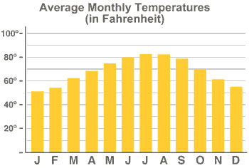
Weather Similarities to Inland South- New Orleans is similar to many parts of the Inland South in that it has a humid subtropical climate. Summers are hot and humid and winters are generally mild.


Average Temperatures and Precipitation
Month
Avg High Temp
Avg Low Temp
Avg Precip
January
62° F
43° F
4.7 in.
February
65° F
46° F
5.6 in.
March
71° F
52° F
5.2 in.
April
78° F
59° F
4.7 in.
May
85° F
66° F
4.4 in.
June
89° F
71° F
5.4 in.
July
91° F
73° F
6.4 in.
August
90° F
73° F
5.9 in.
September
87° F
70° F
5.5 in.
October
80° F
59° F
2.8 in.
November
71° F
51° F
4.4 in.
December
64° F
45° F
5.5 in.


(Source for Confederate information and photo: militaryhistory.about.com)
(Average temperatures taken from http://www.neworleansonline.com/tools/weather2.html)

Monday, March 4, 2013

Chapter Seven- New Orleans in relation to Megalopolis

New Orleans is not one of the cities included in the Megalopolis of Boston, New York, Philadelphia, Baltimore and Washington but it does share some similarities to the area.


Like the Megalopolis, New Orleans is not a homogeneous area.The city has French, Spanish, and Caribbean influences from its diverse historical past, and new immigrants to the area have made New Orleans even more of a cultural melting pot. New Orleans is a city of Festivals that honor various cultural traditions.  Soul Fest pays tribute to African American music, food and culture. St. Patrick's Day festivities honor the history of the Irish people that have made New Orleans their home since the 1840s. The most famous event that blends cultures in New Orleans is Mardi Gras.


Another similarity between New Orleans and Megalopolis is the fact that in  both areas, inhabitants  have been dramatically modified the ancestral landscape. The area of New Orleans was originally swamp and marshland. City builders drained and shored up this area to provide a foundation for development and  growth.  Due to the low lying nature of New Orleans levees had to be built to prevent flooding. Residents of the city began building artificial levees as early as 1726. Congress passed the Louisiana Hurricane protection Project as part of the Flood Control Act of 1965. The project was to construct a series of control structures, concrete floodwalls and levees to provide hurricane protection to areas around Lake Pontchartrain. It was expected to take about 13 years to complete and cost about $85 million dollars.  It was a joint federal, state and local effort.

When Hurricane Katrina struck New Orleans in 2005, the project which included about 125 miles of levees, was estimated to be 60 percent to 90 percent complete in different areas and the estimated completion date for the whole project was 2015.


(Sources: USA today and BestofNewOrleans.com ; photo Google Images)

Sunday, March 3, 2013

Chapter Five- New Orlean's link to the Atlantic Periphery

The Atlantic Periphery is made up of the Canadian provinces of Newfoundland and Labrador, Nova Scotia, Prince Edward Island, and New Brunswick. While this area of North America is a long way from New Orleans, Louisiana, there is a historical link that connects the two areas.

Map of Acadia area of Nova Scotia circa 1776 (Source: Google Images)


CAJUN ('ka:-j@n), n. A person of French Canadian descent born or living along the
bayous, marshes, and prairies of southern Louisiana. The word Cajun began in 19th
century Acadie (now Nova Scotia, Canada) when the Acadians began to arrive. The
French of noble ancestry would say, "les Acadiens", while some referred to the Acadians
as "le 'Cadiens", dropping the "A". Later came the Americans who could not pronounce
"Acadien" or "'Cadien", so the word "Cajun" was born.

Cajuns are people originally from Acadia in the Atlantic Periphery area of Nova Scotia.  Today they live scattered throughout southern Louisiana and they maintain the vibrant culture that the original French settlers from Atlantic Canada were known for.  After the Seven Years' War between France and Great Britain, France had been defeated.  The French Acadians were exiled from land that they had occupied for over a century. This process was known as "The Great Disturbance". The exiles settled  in many locations including  the British North American colonies, France, England, the Caribbean, and for some , a Spanish colony known as Louisiana.

While the Cajuns lived in what was to become a predominately English speaking country, they held on to their language throughout the 19th century. Cajun French was largely spoken in the home. The Louisiana state Constitution in 1921 required that  school curricula be taught in English statewide, which greatly reduced exposure to Cajun French to young people.

Cajuns are known for their cuisine which along with Creole food is legendary in New Orleans. Famous dishes include Crawfish Etoufee, File Gumbo, and Jambalaya. Crawfish boils are popular as are dishes incorporating Andouille and Boudin Sausages.


Picture of Crawfish Boil Recipe(food network photo)

For several generations, the Cajuns raised various crops and lived on the bayous where they fished and trapped. Today, Cajuns are famous for their unique French dialect, their music, their spicy cooking and for their ability to live life to the fullest. As the Cajuns say: Laissaz les Bon Temps Roulez!
or
Let the good times roll!


Information sources: About Geography.Com, The State of Louisiana website and Geography of North America Text (Hardwick)
 

Friday, March 1, 2013

Chapter Four- Political Economy

New Orleans is home to one of the world's busiest ports. The region is also a major center of oil refining and petrochemical production. New Orleans is home to the regional headquarters of several major energy companies including Chevron, Royal Dutch Shell and ENI. The energy sector supports numerous engineering and design firms. The offshore and onshore petroleum and natural gas production sector provides numerous white collar jobs.

The Federal Government is a significant employer in the area. The New Orleans region is home to NASA's Michoud Assembly Facility, the National Finance Center, the U.S. Navy's Space and Naval Warefare (SPAWAR) Systems Command and the U.S. Fifth Court of Appeals.

Aerospace manufacturing is an important part of the economy. Martin Marietta manufactures aerospace components for NASA. New Orleans also includes a globally competitive manufacturing industry. Also, some of the top private employers are shipbuilding companies.

Other prominent elements of the economy are higher education, the large health care industry, the prominent tourism industry, and research and technology.

Images:Google /Info:cityinfo.com